
I flew the TB20 from Shoreham (EGKA) to La Axarquia (LEAX, also known as Velez-Malaga) to stay with some friends who live in the nearby town of Frigiliana.
Outside the UK, this trip was flown under VFR.
The Aircraft
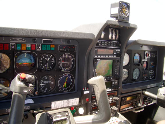
This was a Socata TB20, with 140kt IAS cruise at 65% power (10.5GPH fuel flow) and endurance of about 8 hours at that power setting. It has an autopilot with altitude and vertical speed hold, tracking a heading, GPS or VOR track or an ILS. The GPS is a KLN94 with a KMD550 multifunction display (the MFD is visible in the instrument panel picture below, in the centre stack). The aircraft also has a WX500 stormscope, an ADF/VOR RMI, and a TKS de-iced propeller.
The pilot has 500 hours total time, 400 on the type.
Navigation
Navigation was entirely IFR, without reliance on visual ground references, using the KLN94 GPS with VOR/DME/ADF support as available. I have not navigated VFR since my PPL skills test 5 years ago. Unfortunately, given a "VFR" flight, ATC often require reporting at specified visual reference points. For this reason and as a general backup for the primary GPS, we also used a second battery powered GPS running on an ix104 tablet PC and displaying either scanned charts or the Jeppesen electronic charts. On a lot of routes, there is no ground based navaid available (or the navaid is out of service) so a backup GPS is desirable; also while the KMD550 moving map does show most airspace / danger area boundaries it doesn't show everything.
The route was planned on both Navbox Pro (without a doubt by far the best European VFR flight planning program) and on the very much more expensive Jeppesen software, so the tablet PC (driven by a second GPS receiver with its own roof-mounted GPS antenna) displayed the aircraft along the planned route. When I first looked at the Jeppesen software, I was hoping that the FliteMap VFR chart display would be a usable substitute in-flight for the printed chart but while it can be much more current (due to electronic updates) it falls far short on detail. This software is usable alone for IFR flights, where weather, icing levels, MSA, and getting the IFR route accepted by Eurocontrol, are almost the only considerations. But since IFR charts are cheap (they cover huge areas) one may as well buy them anyway.
The route illustrations in this article are screenshots from Navbox.
My normal method of navigating in unfamiliar places is to fly the aircraft on autopilot (tracking the heading, rather than a GPS track although I do the lattter on long legs), follow the progress with occassional glances on both the primary (panel mounted) and the handheld GPS, and check each bit on the printed chart which I have on my knees (and which has the planned route drawn on it). It's a great system and in 450 hours I've never been lost, or even unsure of position. One is able to look out of the window nearly all of the time. If an autopilot is not available, one can do the same thing but the workload is a bit higher.
Charts
For the UK, the CAA charts are the best.
For France, I use the 1:1M SIA charts as these are generally regarded as the most "official" - important if I ever get into trouble there. They are a pain to use because they don't show the vertical extents of the various bits of military airspace - these have to be looked up in a separate booklet, and planning a route which lies outside the standard "airways" can take hours. I have used the Jeppesen VFR/GPS charts in the past and it's a personal choice. The French IGN charts are very pretty but useless because to go only up to about 5000ft.
For Spain, I use the 1:500k Jeppesen "VFR/GPS" charts. I also use these for everywhere else; they stretch all the way to the end of Italy and past that one has to use e.g. the U.S. ONC charts.
I also carried the Jeppesen Bottlang VFR touring guides; they tend to be not too inaccurate in the approach diagrams, even though they are poor for phone/fax numbers for which I prefer to use Navbox. They are very heavy and not available in electronic form.
Planning
This trip had identical departure and destination airfields to one done in 2003, written up here. However, it was planned in a different way, to take more advantage of clearances (into Class D and into military airspaces) which can be obtained en-route, and specifically to explore a VFR route through France that uses the French "airways" to get around the extensive network of military and other restricted/prohibited airspace which covers much of France.
The entire route planned out at 6:40 hours (zero wind) and could be flown in one leg at a 150kt TAS with legal reserves. However, a trip of this length is not comfortable and it leaves only one hour fuel reserve whereas I never fly with less than two hours. So a rest/refuel stop was planned. Two obvious mid-point choices are Biarritz (LFBZ) or San Sebastian (LESO).
As the aircraft is N-registered this time (was G on previous trips into France), and N-reg pilots receive a lot of harrassment from French Customs, and an inspection - even a friendly one, not ending in grounding of the aircraft pending the delivery of documents - had the potential to mess up the time/weather planning on such a short trip, I decided to avoid landing in France altogether. Obviously I do want to visit France, and I carry all imaginable documents including a Free Circulation Certificate, but unless I am on a trip where I have time to spare this will inevitably remain a small flight planning issue.
San Sebastian proved to be an excellent choice, because as I discovered company owned planes routinely receive fuel in Spain at around half price - around Euro 0.77 per litre - especially if paid for by the BP aviation fuel card. I also know from a frequent visitor there that wearing the proper pilot uniform helps at the larger airports but I did not have the opportunity (or the clothing!) to verify this.
To enable checking of weather for the following day and filing of flight plans, all without having to leave the hotel, it is highly desirable to have mobile internet access in the form of a laptop or a tablet computer with GPRS. I have this one (a £300 refurbished 1.5kg Dell with a £100 GPRS card) and also have an HP 4700 PDA with a 640x480 screen and built-in WIFI, which worked OK for internet access where WIFI was available but one cannot run any decent flight planning software on a PDA. Beware with PDAs: a lot of websites don't display correctly on the Pocket/PC version of Internet Explorer, and most PDFs cannot be viewed. WIFI access points were as common as everywhere else nowadays but very few of them were free or unencrypted, whereas GPRS worked reliably. It's expensive per MB but it works and gives you independence. With a laptop one can get everything in one, by plugging in a PCMCIA GPRS card, or a PCMCIA WIFI card. I have been experimenting with the ix104 tablet computer as an all-in-one device for ground based flight planning and in-flight use as a GPS moving map and an approach plate display (JeppView) and, while it does do the whole job, it has various issues which make a lightweight laptop more useful for everything on the ground.
A previous and more complicated trip, which raised the "flight planning on the move" issues more strongly than this one, is here. The general idea is to avoid having to spend all of one's evenings doing flight planning for the next leg!
For filing flight plans via the internet, I use this really excellent Austrian website: http://www.homebriefing.com. They charge a flat rate of about Euro 36 per year which is peanuts on the scale of flying costs, and it saves a lot of hassle. They aren't the only means of filing a flight plan electronically; the French Olivia is another example, but Homebriefing is the only one which to my knowledge offers to file a flight plan which is entirely outside the country in which the particular ATC unit is located (Austria, as it happens). They have confirmed this to me in writing. Other offices such as Olivia, or even the Heathrow Airport fax filing facility, are not obliged to accept a flight plan that lies entirely outside their country. Homebriefing works very well, with an indicator on the site that changes colour once the flight plan has gone into the system, and they can even send you a text message or an email to confirm. None of these sites are a direct gateway into the AFTN (the worldwide network used to transmit flight plans and other stuff); as far as I can tell the submitted plan is still processed manually by ATC staff in Vienna.
Last time I did this trip, in 2003, three out of the four flight plans (all filed conventionally, using the Shoreham flight plan filing terminal) vanished in the system which caused me some hassle on the relevant departures. This time, only the LEAX-LESO one did; apparently due to an addressing error. Homebriefing have been very responsive on this; clearly this is the future for anyone doing a reasonable trip away from home.
For weather I used Avbrief and this GFS site. This site in Wyoming (of all places!) is also very useful for Skew-T diagrams. For Region, select Europe; for Type of Plot select GIF: Skew-T, and you get what amounts to a METAR map of data gathered from met baloons. The generated diagram shows the profile of temperature and dew point versus height and this gives an immediately obvious (and accurate, at the time) figure for the cloudbase and cloud tops, freezing levels, etc. The Dundee satellite station is one of many sites offering satellite images of various earth regions; great for seeing where the cloud cover is.
For notams, I use the UK AIS website, and do only the Narrow Route Briefing. I did a briefing for each of the four planned legs, and for each one, in the UTC Validity Period boxes I entered the start and end of the entire trip, to make sure stuff got picked up even if we changed the timing a bit. It's important to realise that the UTC Date/Time of Flight boxes don't do anything as far as selecting notam data goes!! User-defined waypoints (such as the two used in the EGKA-LESO route) are specified either using nearby airways intersections or, if none are nearby, VOR radial/distance parameters (e.g. the TMP01 waypoint mentioned below is specified as BMC270022 - 270deg, 022DME from the BMC VOR)..
Shoreham (EGKA) to San Sebastian (LESO)
The first leg was EGKA NEVIL CAN ANG RY TMP01 TMP02 LESO where NEVIL is the UK FIR boundary, TMP01 is a point on the west coast 200 degrees from RY, and TMP02 is another point on the coast just north of Biarritz.
It was flown at FL065, descending to FL045 before ANG and 3000ft before RY. On this route, one has to carefully check the military airspace but it's easy enough and worth doing for the very picturesque section along the long western coast. In general, this route is possible only at weekends because the whole second half is within restricted airspace (e.g. R31A1) which is active during the week. One can establish the activity of R31A1 on the initial call in French airspace (e.g. Brest Info) and one needs an alternative plan ready if R31A1 is active. My alternative plan was slightly more inland but there one has to be incredibly careful because of the Les Blayais / Le Barp prohibited zones. In practice I would have probably flown the "airways" route which is shown at the end of this article and which was used for the return flight.
I didn't include the estimated time to the second FIR boundary (between France and Spain) because it lies just a few miles before the destination, and nobody queried this so presumably they have some common sense.
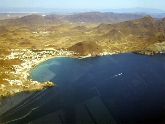
The notams picked up some parachuting and aerobatics along the route but all below the planned levels. As we approached Biarritz, we encountered low cloud, about 1000ft, as is quite common in the Bay of Biscay (and it can hang in there for days, leaving all VFR pilots stranded if low enough). We flew under this just offshore, and in any event the San Sebastian chart specifies the approach to be made below 1000ft QNH. As the wind was right across the runway, we were offered 04 or 22 and 22 was obviously much easier, approaching from the sea:
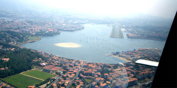
We asked for fuel while still in the air, were asked to follow a vehicle after landing, and the fuel bowser with a very polite man turned up immediately. We were out on the street, refuelled, within half an hour of landing!
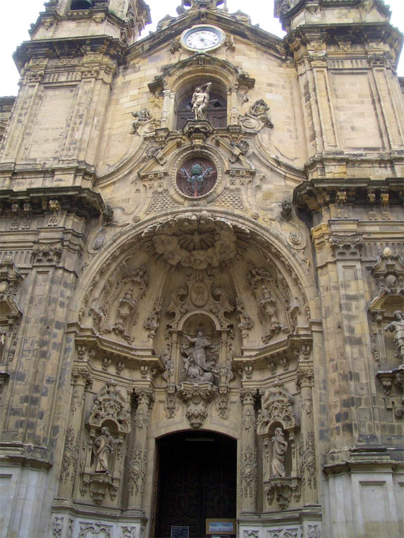
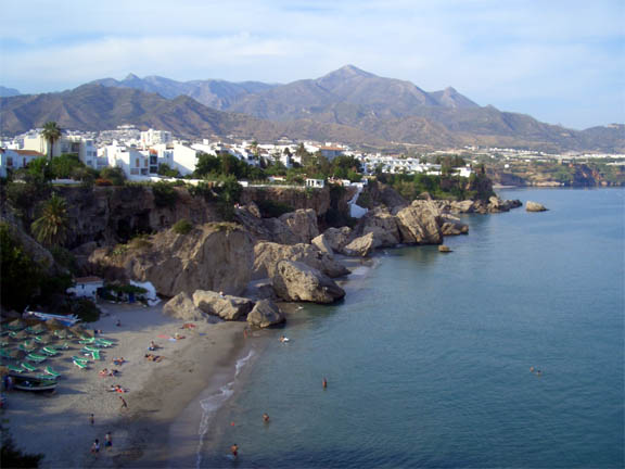
San Sebastian is a very interesting town, with plenty of places to hang out and some interesting architecture:
As is normal in the southern bits of Europe, there is a lot going on in the evenings. The warm weather obviously helps but one easily notices the large numbers of children playing apparently unsupervised on the beach and elsewhere, without the groups of bored teenagers, aggressive street scenes and fashions that are normal in the UK. We could have certainly managed to stay there for a week.
We stayed there overnight, departing for La Axarquia around 9am the following morning. One has to walk upstairs to the office in the main building to pay the landing and parking fee (Euro 20 total, most reasonable) and they give you a stamped invoice without which you cannot get out airside again!!
Unfortunately their "system" is also set up to not let you out airside unless you have a copy of the flight plan similarly stamped (understandable since in Spain you need a flight plan for everything outside Class G - the relevant Spanish AIP reference is here, page 3, also at http://www.aena.es) but I didn't have that since I had already filed my flight plan over the internet! Most pilots don't have this facility and use the airport facilities for weather, flight plans and everything else, so clearly this works for them. We managed to get out eventually, despite a very irate security guard who needed a translator. On the return trip we discovered that a better way is to get the office to retrieve the already-filed flight plan (which they should already have by then) and put their rubber stamp on it for the security man downstairs...
San Sebastian (LESO) to La Axarquia (LEAX)
This was LESO PAP VAB YES GDA LEAX and was flown mostly at FL105.
The VAB VOR was out of service, according to the Notams, and sure enough it was. Unlike most VORs in France, Spanish VORs do have DMEs like in the UK.
There was low cloud hanging around the San Sebastian area and we flew under it for a few miles along the coast to the west. Upon climbing we got an amazing view of the mountains sticking up through the clouds, with wind turbines on top
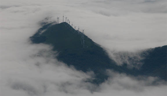
The clouds didn't extend inland by more than a few miles, though flying above the above scenery would have presented interesting engine failure options!
One ends up crossing a few restricted areas, notably D131/D132 which are the hardest to dodge due to their vertical extents. I tried to get permission in advance by fax to cross these from Albacete (LEAB) and while the man there was very responsive, promising to get a response to me from his boss and even suggesting an alternative route by email (which we could not use due to the Alicante Class A), nothing actually happened prior to our departure, not even after a phone call that morning. So we set off planning to go around them (easy with a GPS showing the actual or equivalent chart) and when we asked for transit (Madrid Control) we got it within minutes...
At FL105 we used oxygen, in the form of an Aerox portable oxygen kit, which makes a big difference to how tired one gets. We got through half the bottle on this leg, with the flow rate on each of the two cannulas set at 10,000ft.
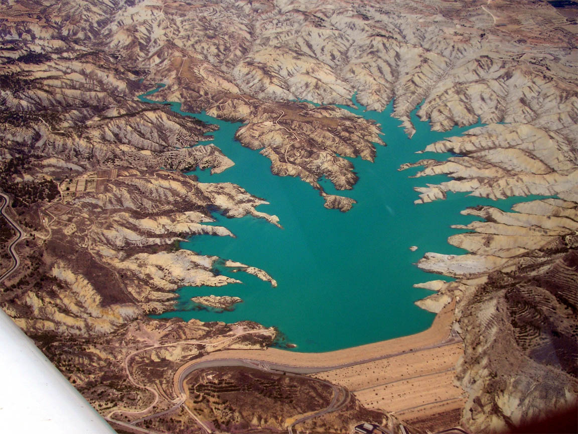
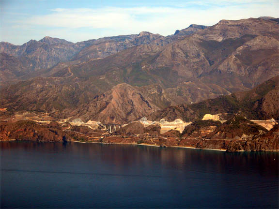
The scenery over Spain was spectacular, with a suprising number of lakes despite the rugged and often barren terrain:
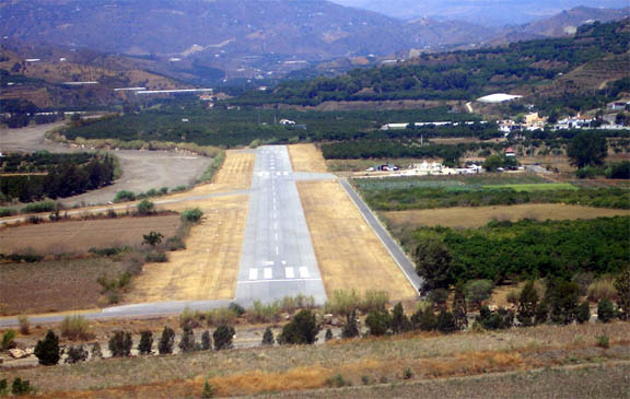
The final descent into La Axarquia is good fun, dropping from some 8000ft to nearly sea level in just a few miles. Engine management is always an issue but if one drops the landing gear at 8000ft and gradually reduces MP to 16", one can get down easily enough without excessive engine power reductions and without additional orbits if landing on 31. A landing on 13 (the preferred one for the prevailing wind) would have needed at least one orbit to get down. We landed slightly downwind on 31 but the wind was very light.
It is a very sleepy airfield with almost nothing happening, and it was HOT!! I was pleased to see they had trimmed the grass near the end of the runway (where one does a backtrack) in which fence posts used to hide...
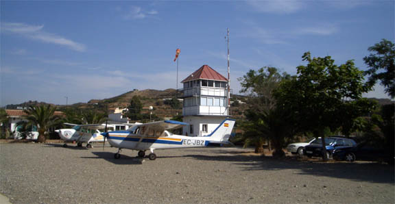
A very helpful fuel pump attendant happened to be nearby so we got filled up right away. Nobody showed any interest in receiving a payment for landing and parking so we went straight out. The flight plan had already been closed by Malaga (LEMG) Approach which was our last contact frequency before changing to LEAX where nobody answered the calls.
There is a huge amount of construction work going on in this part of Spain (and elsewhere), prompting lots of debate in the local media as to where this is leading to. It is likely that the party is coming to an end; one ex-Spanish estate agent, now back in the UK, reported four great years and one lousy one. For Sale or Rent signs are everywhere. The advertised house prices are now fully Sussex prices but are coming down. Apparently, the national bird of Spain is the crane :)
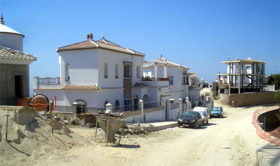
But it is still a great place to visit, and would be a super place to retire to if one had enough money to not need to do any work, and wanted a very laid back lifestyle. In the right location, and at a price, one could get spectacular views. I'd guess the cost of living is around 50% of the UK, especially if one consumes a lot of alcohol which is a fraction of the UK price.

I am not entirely convinced about the concept of a private pilot living in this part of Spain. While the weather is usually very good, they don't have anywhere near as many airfields as the UK and, from this part of Spain, France is a good 3 hours in a fast single engine aircraft. It is no suprise that the property development scene is largely driven by airports served by cheap airlines. For the last few years, some developer has been working, very slowly, on an air park inland, in a location where one would probably not want to live!
La Axarquia (LEAX) to San Sebastian (LESO)
Before departure, I phoned Malaga to check they had received the previously filed flight plan but they had not, so I filled in a new one which was faxed using a dedicated fax machine at the club house, and someone there then phoned Malaga again to make sure they had it. After paying a miniscule landing and parking fee, we departed on 13. The route was originally planned LEAX AMR VSJ VAB PAP LESO but we decided to turn north before VSJ (immediately before the Class D there), proceeding all the way to PAP and avoiding restricted areas D131 and D132 in the process.
The LEAX-AMR route was flown along the coast at 2000ft, with spectacular views
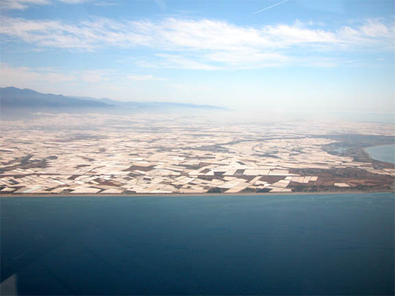
Parts of the coast are covered by a huge amount of what looks like greenhouses:
As we turned north we climbed gradually to FL075. At this level we encountered two huge vultures!! This part of Spain is relatively more barren. It was great to be at altitude again, due to the heat. Even at FL075 the OAT was +18C.
Upon landing at San Sebastian, the shutdown checks revealed a duff spark plug on #3 cylinder. It would not clear using the standard procedures (leaning under high power) and there was nobody about who could help. Our only option was to go to a DIY shop and purchase tools to remove and clean the plug, which meant a day's delay and a serious problem with the return to the UK due to forecast stormy weather. In the event of a grounded aircraft, there were few options for getting back to the UK; perhaps a train to Biarritz and then a flight from there... However, upon a second engine start (to look at the problem more carefully) the plug was found to be fine. A mystery then. These are iridium spark plugs, too, £50 each! We got fuel as promptly as before, paid the fees (Euro 8 for the landing), had a cup of tea and went off again.
San Sebastian (LESO) to Shoreham (EGKA)
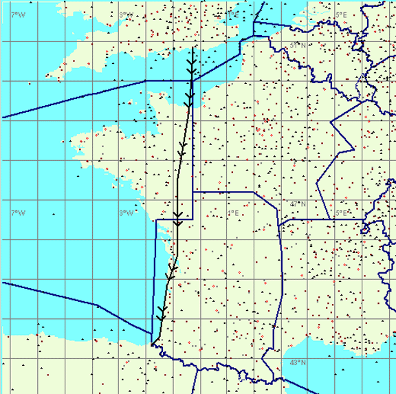
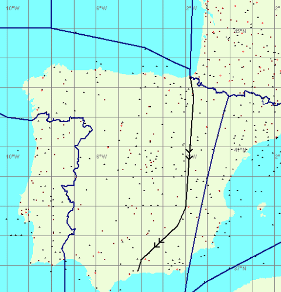
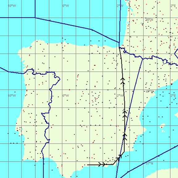
The final part of the route was LESO BTZ SAU LMG AMB LGL DVL SITET EGKA where SITET is the UK FIR boundary. It was flown mostly at FL065. This used the "airways" to avoid the extensive military airspace in that part of France.
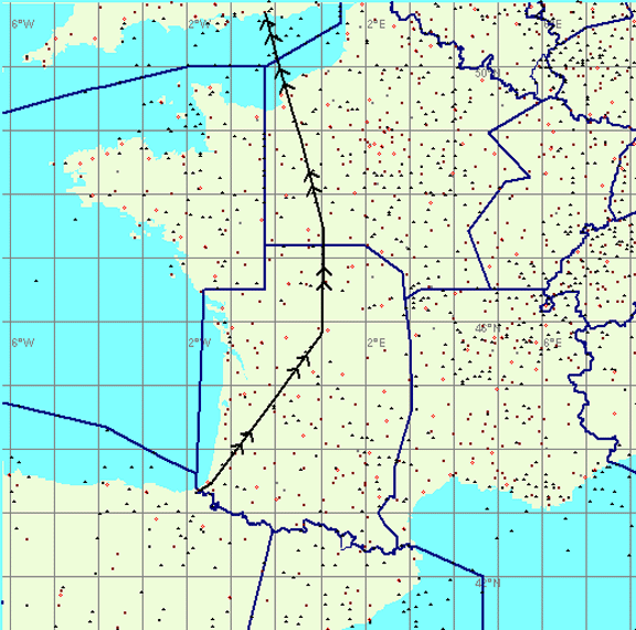
The following French SIA chart section (click on it to see an enlarged version) shows an airway R10 from the BTZ VOR (bottom left) to the SAU VOR (top right). This airway is also marked FL065 and this is the lowest level at which one can fly it and clear the various obstructions. Quite possibly this level is also designed to ensure reception of the two VORs.
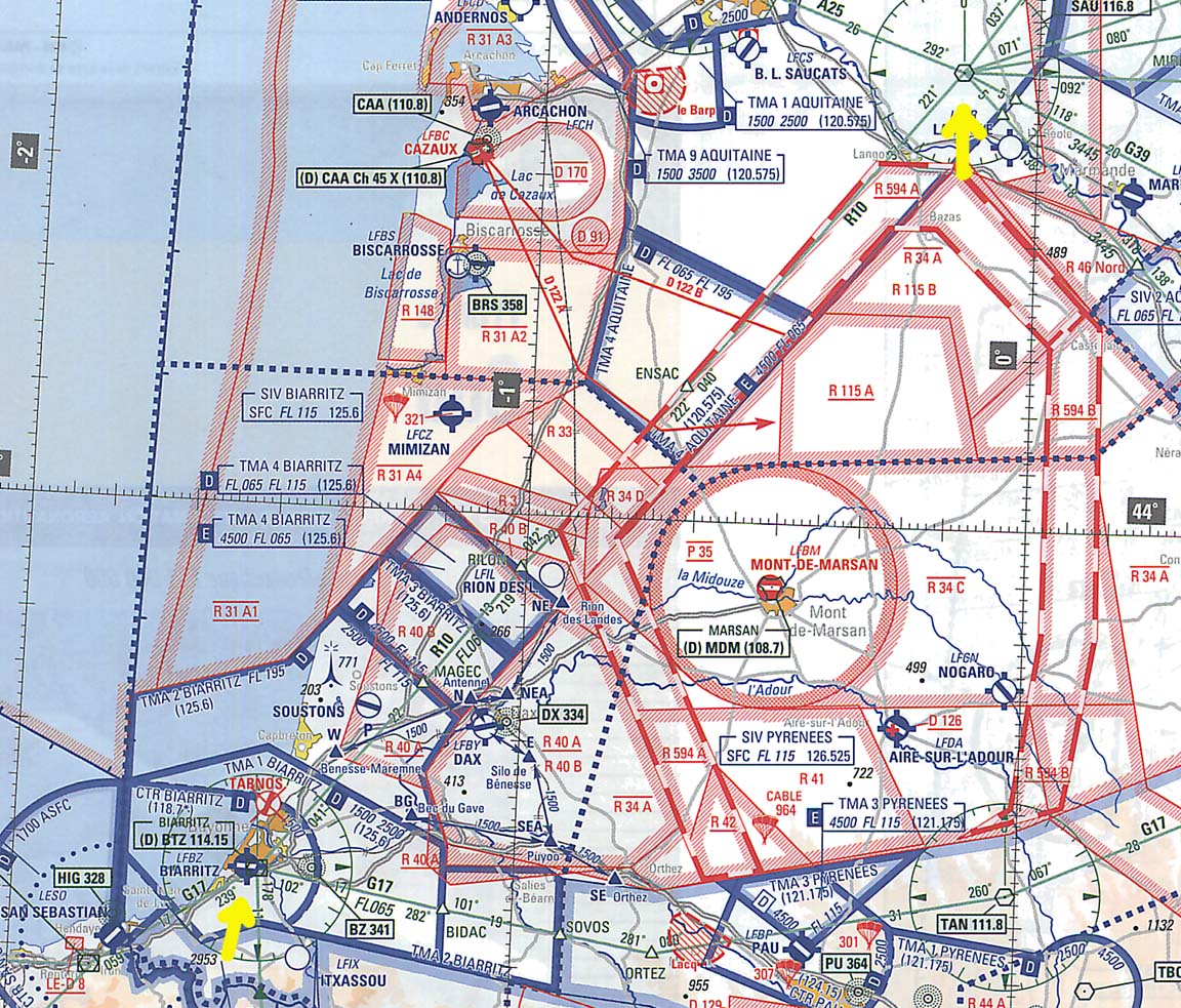
In general, following these airways will clear the restricted airspace, and any additional restrictions should turn up in the notams which one still has to obtain as normal.
However, it is also clear that there is a lot of Class E and Class D about affecting these routes. Class E isn't a problem because a VFR flight doesn't require a clearance (or even radio contact), but Class D does require a transit clearance. However, while in the UK Class D transit is very rigidly controlled and an explicit clearance is most certainly required to enter it, in France they seem very casual about it. You just tell them "routing direct BTZ, then direct SAU, FL065" and the reply is something like "Roger, squawk 2345" and apart from "Radar contact" some seconds later that's the last you hear. I am told this is less likely to work around busy airports such as Toulouse and Lyon!
The above means that flying in CAS (controlled airspace) in France is a lot easier than doing the same in the UK. In the UK, most VFR pilots go to great lengths to stay in Class G and to avoid CAS; understandable given that transit is often not granted so one has to execute a last-minute dogleg around it.
I can think of two gotchas with the above: If one doesn't get transit, one obviously has to wait outside for one, or re-route. There are a few places where a re-route may be impossible, due to immediately adjacent (and active) military airspace, and then one would have to fly back out along the airway. The other one is that if flying at FL065/075/085 etc, one is quite likely to be VMC on top (VMC above an overcast layer and out of sight of the surface, where permitted by the local regulations, is legal for a UK PPL with an IMC Rating even though the IFR privileges of the IMC Rating are valid in the UK only; reference for this is an email I have from the CAA) and this means the weather at the destination has to be good enough to allow a descent while keeping clear of clouds!! If you reach your destination VMC at FL065 and the cloudbase there is overcast at 3000ft, you have no options that would be legally VFR. However, there are plenty of other ways for a pilot (whose privileges are limited to VFR when abroad) to get snookered, so good planning is essential. These caveats mean that if there is any doubt about the cloud cover at the destination, it may be safer ("safer" in the legal sense, not in the aviation sense) to fly a low level route to France, and use the airways (high level) route when returning to the UK.
There was no doubt that this is the way to fly distances in France. We had no problems except at one spot near Tours which had an answering machine on the frequency but we got cleared by Paris Control (in the French way where "radar contact, advise if changing level" amounts to a clearance).
There is no Radar Information Service (RIS) in France though they occasionally offer some traffic information. A lot of British pilots were asking for an RIS and I thought it is a shame that UK PPL training provides such poor preparation for a pilot wishing to fly somewhere interesting.
Only two other light aircraft were seen on the entire trip described here, and none were seen (or heard on radio) in Spain. A huge contrast to the UK, with its heavy radio traffic and machine-gun-like ATC!
Flight times (airborne times)
EGKA-LESO 3:20
LESO-LEAX 3:20
LEAX-LESO 3:40
LESO-EGKA 3:20
Lessons learnt
The flights were uneventful so nothing specific on flying itself. Apart from the spark plug thing, the aircraft performed flawlessly.
Next time I will carry a spare spark plug and the tools to clear or change a plug (it's a 2-person job anyway to remove the cowlings). Plus a toolkit for other repairs, many of which I can do now that the aircraft is N-reg. A TB20 with two adults can carry a huge amount of junk - in our case we could have carried 130kg of stuff at MTOW.
Refuelling stops should be short - make the best of any known good weather! If you want to stop somewhere, make it a few days so you don't worry about the weather - because you can't; weather cannot be usefully forecast a few days ahead, especially for the Bay of Biscay where low cloud (say OVC006) can appear despite synoptic charts showing a nice high pressure. I found the NOAA GFS weather site to be very accurate on this, predicting exactly when the low cloud at LESO would clear for our return journey.
The "airways" route through France worked particularly well. My previous trips were planned meticulously outside controlled airspace, at the cost of having to wade through tons of restricted airspace. But one must be really careful doing this - there may be no chance of getting underneath any cloud cover before reaching the destination!
Flying at weekends is a lot easier because much of the restricted airspace is inactive.
One can often get instant transit through restricted airspace when calling up in the air, having failed to achieve anything by phoning, faxing and emailing.
There is no doubt that a decent GPS is absolutely essential for this kind of trip. Visual navigation is just too error prone.
It clearly pays to ask for fuel while still airborne and get filled up right after landing. The larger airports don't like people hanging around airside (a man in a van soon turns up) so make good use of this attention and don't walk away from the aircraft until you have fuel.
There is no doubt that flying IFR is much easier around Europe, keeping the VFR option for routes where the weather is clearly nice and one wants to get away quick without messing about with IFR flight plans.
Update 10/2011: San Sebastian airport is no longer an "Airport
of Entry" (even though its AIP entry shows it has "Customs")
and thus does not accept international traffic from outside the Schengen region.
This situation, which is confusingly documented in various airport guides including
Jeppesen, is the result of "one type of policeman" turning up for
work and "another type of policeman" not turning up for work ![]()
Last updated 18th October 2011.
Any feedback, reports of dead links, corrections or suggestions much appreciated:
Contact details
