Objective
This trip was similar to the one to Crete in 2004. Again, we wanted to visit a number of interesting locations along the route. To allow for unforeseen weather, we decided to stop only in those locations that would be interesting if one got stuck there for a few days, and to keep the leg distance as long as possible in between to make the best use of the great range (800nm plus, with ample reserves; c. 1300nm to zero fuel) of the TB20 aircraft.
Outside the UK, this trip was flown under VFR.
Following requests from non-pilot readers, here's a glossary.
This trip is probably going to be the last one done VFR. Very soon I will finish my FAA IR [edit Feb 2008: I now have the FAA CPL/IR]. The aircraft is already on the N register and I have the standalone FAA PPL (as well as all the UK VFR/IMC stuff). The IR, which I tried to do entirely in the UK, first in a G and later in an N, has taken much longer to finish than originally expected, due to myself being busy at work and due to the UK CAA gradually shafting (during 2005) the FAA training options. In the future, I will fly VFR when the weather is great and I wish to take advantage of the reduced flight plan filing time and greater routing flexibility. The rest of the time I will go IFR and take advantage of the greater weather flexibility, particularly on departure and arrival. However, the aircraft is not fully de-iced and with a practical ceiling of about 18,000ft it will never match the reliability of commercial travel!
As a lot of the details of this trip were similar to the Crete one and were written about in great detail there, with loads of URLs and other references, I am not duplicating them here. This time, a number of things were done differently based on lessons learnt on previous long distance trips. These included:
More use of controlled airspace (CAS) transits. A UK pilot is heavily conditioned by the PPL training establishment to avoid controlled airspace (CAS). This is probably (excuse my cynicism!) because the instructors are well aware that the training they are selling is much too basic to be any good for "going places", and the vast majority of new PPLs chuck in flying permanently within a year or two, so it's best to not encourage them to be too clever. This is just about OK in the UK where many pilots have never ventured outside Class G and indeed one rarely has to to fly from A to B, but is no good abroad where (in many places) there is so much CAS that picking a route through it is a huge exercise, and often any such route is so complex it would be navigable only with blind reliance on a GPS and airspace depictions thereon. Fortunately, outside the UK it is much easier to get a transit through CAS and this makes routing far simpler than would at first appear.
Much better ground communications. Mobile internet access is a must for any long trip, so one can get weather, notams, file flight plans, fax PPR (prior permission required) information to airports. Last time I was relying on a temperamental 9.6k GSM modem. This time I had GPRS (PCMCIA card in a laptop) which worked flawlessly everywhere and saved a huge amount of time. 3G (a much faster version of GPRS) is another nice toy but the present coverage is so poor it's a waste of time. I also had WIFI which was great on the very rare occassions that the hotel or a cafe had coverage, and it allowed me to deal with business emails by running PC/Anywhere over a secure VPN.
Pre-plan routes before leaving home. It is always quicker to slightly modify a route than to plan one from scratch. Also, unless one can carry a portable printer (there are no really usable portable printers on the market, and the "portable" units currently out are slightly ridiculous) one spends a lot of time manually copying out the route plan from the PC-based flight planning program.
Electronic charts. Over the last year or two I have examined various in-cockpit display devices for VFR charts, IFR routes, and instrument approach plates. For Europe, the only realistic product for this is currently the Jeppesen range and I used FliteMap IFR with the fully up to date European Raster Chart add-on. This stuff proved only just about usable and in the end I still used printed charts for route planning and in-cockpit use, with FliteMap on a Windows XP ix104 tablet computer, or OziExplorer on an HP4700 PDA, providing a display of current position over the most recently available VFR chart.
Contact the major airports en-route. The time to discover that most of the numbers in the Jeppesen Bottlang flight guides are useless (because they were lifted out of the national AIPs, without anybody checking them) is at home, not when sitting in a hotel en-route. This time, I phoned (or faxed, if there was nobody English-speaking there) each planned destination with aircraft details and approximate dates and asked if there is anything I specially need to know. I also phoned the ATC unit at major airports along the dodgy-looking route along the coast of former Yugoslavia to check what route is likely to be permitted. These contacts proved to be very easy and exceedingly helpful.
Planning
The trip was planned to be navigated fully IFR i.e. with GPS as primary, backed up with VOR/DME/ADF navaids. I never navigate using traditional VFR methods - they are too error-prone and stressful as a result. So the routes were planned, as far as was practical, to lie on VORs or NDBs. If none of these were around, IFR intersections (e.g. NORKA) were used as ATC are fully familiar with these, expect them to be used in many places (Greece in particular) even for VFR traffic, and their use demonstrates that the pilot knows what he is doing which always helps! The routes were planned on the assumption that any CAS transits will be permitted but with the "refusal" options being allowed for.
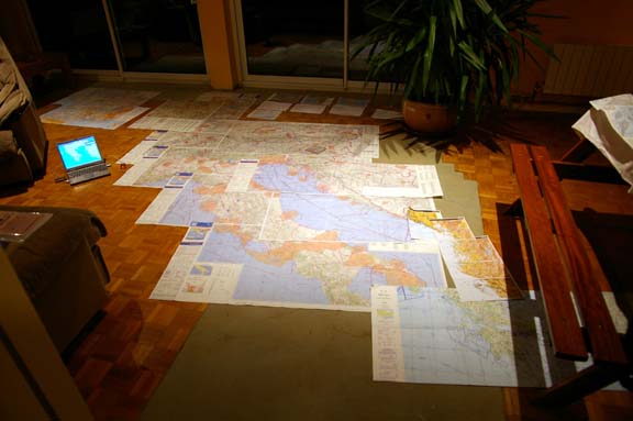
One a trip like this, the charts, stuck together temporarily with small pieces of adhesive tape, cover a lot of floorspace:
The route was planned on Navbox Pro - far and away the best European VFR flight planning program. It is fast to use and produces clear and easy to use plogs (route/waypoint/distance listings). However, as I was also evaluating the Jeppesen FliteMap alternative (for future IFR purposes), I duplicated each route plan in FliteMap to see how the two programs compared in usability. The route images in this article are from FliteMap; each one includes the vertical route profile which shows terrain and controlled/restricted airspace. The vertical profile looks rather pretty and might just be handy in detecting a gross MSA planning error. FliteMap is the same as FliteStar but it can also work as a GPS driven moving map if GPS NMEA data is available.
There is a fully electronic alternative to paper charts: the Jeppesen Raster Chart add-on for FliteStar/FliteMap. This costs about £200 for Europe - about half the cost of the equivalent paper charts from Jepp. Its coverage is the same as their "VFR/GPS" charts i.e. up to the end of Italy; past that they pad out the coverage with the out of date U.S. ONC charts which are reproduced in poor quality and contain only the (out of date) danger areas, no CAS. In fact the entire product is rather poor; even the mainstream European data appears to be a manual scan of the printed charts, complete with JPEG compression artefacts.Jeppesen have just discontinued FliteMap, forcing users of the GPS moving map feature to purchase the pricey Jeppview-3 / FliteDeck product (which cannot run the Raster Charts); this seems a stupid move given there is now no other way to display their Raster Charts as a GPS driven moving map. However, the Raster Charts do provide an alternative to printed charts, and one can print out en-route chart sections. I have not used this product to avoid the paper charts because it's expensive to buy the whole CD unless one really is flying all over Europe all the time. One source for Flitestar and the Raster Charts CD is Pilotshop. Jeppesen still sell Flitestar (VFR and IFR) and this is the only product which can use their Raster Charts.
The above is concerned with navigation. Other requirements are the carriage of a life raft for the inevitable long over-water flights, a portable oxygen kit for flight anywhere above about 10,000ft, and a handheld radio and a handheld GPS in case of an electrical failure.
Routings
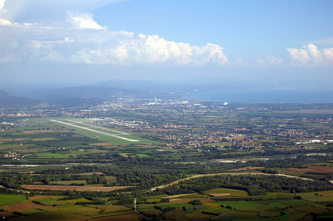
The first destination, Trieste, was chosen simply because we wanted to see it. My father worked there shortly after WW2 and always spoke very fondly of it - and of Italian women... On the way out to Trieste, we could have routed via Belgium, or via France. The relevant part of France (bordering with Belgium) is covered in military airspace but has no "airways" so it would have been a case of picking one's way through it using the SIA charts and the accompanying handbook. As the flight was likely to be on a weekday, much of it would have been active. So we decided to route via Belgium.
One look at the airspace in Belgium suggests that no general aviation activity can possibly exist there! Most of the country is covered in controlled airspace (CAS) down to low levels. This is also one of the busiest airspaces in Europe. I telephoned a few ATC units there and asked whether they would allow transit; the answer was an immediate "yes of course, it's Class D or Class C and these are OK for VFR"!! So, I decided to go on the basis of getting some reasonable clearances - something one could not do in the UK where "own navigation, remain outside controlled airspace" (in other words: sod off) is common enough. Anyway, there are routes through it; though often at below 1000ft.
Navigation
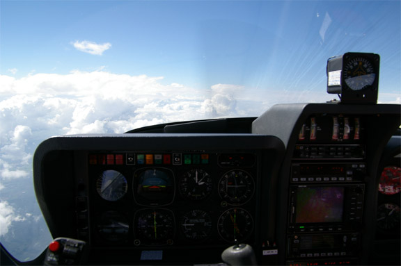
GPS is the primary means of navigation. Anything else is frankly idiotic, on any flight other than the trivial. The aircraft has the excellent Honeywell KLN94 and the KMD550 multifunction display, all panel mounted:
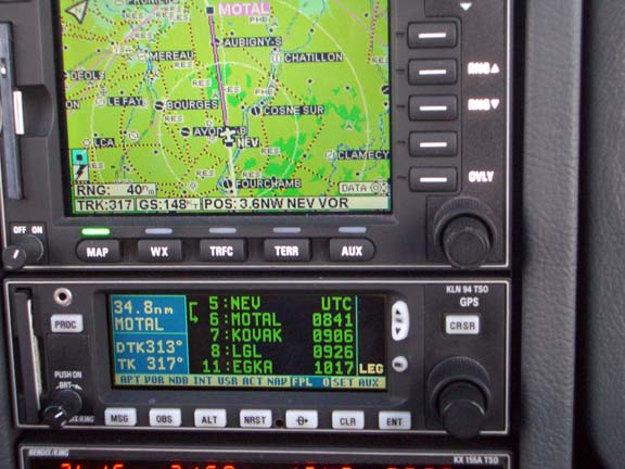
The GPS is backed up by ground based navaid reception whenever available. These are displayed on an RMI, CDI, and DME which are in the centre of the following picture; one above the other. The KI229 RMI has two (ADF and VOR) needles - a superb instrument which is not cheap but is worth every penny.
I also tried running FliteMap on a tablet computer in the cockpit. I have an ix104 ruggedised tablet which runs all the usual Windows applications, as well as having GPRS, WIFI and GSM fax connectivity. My preference remains for a conventional laptop for all ground based flight planning and communications (it has a decent keyboard, for a start) but a laptop cannot be used in the cockpit. If the ix104 worked well, this would make an excellent solution for a backup for the KLN94/KMD550 GPS (whose maps are very sparse) and would also provide immediate navigation in the event of an electrical failure. I do like having a second GPS in the cockpit, constantly available, and loaded with the planned route.
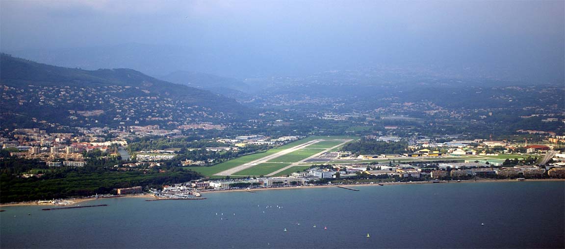
Shoreham - Trieste 13/9/2005
The plan was to depart two days earlier, but questionable weather over the Alps delayed us. We finally departed in what I regard as very nice weather although the lack of a horizon due to haze seemed to cause some pilots to abandon flights to France. The MSLP chart for the day of departure showed that there would be very little wind over the Alps. As normal for any long flight we also got TAFs and METARs for various airports along the route, plus the SigWX chart above FL100.
A phone call to Trieste (as usual with airports and flight guides it took a while to get a working number) suggested that they like a fax a few hours in advance to arrange things, so we did that to 0039 0481 773 304.
The route (FliteMap image) was
EGKA LYD KONAN KOK MAK DIK PITES MAPIG KRH SUL KPT FUSSE MATAR WP1 LIPQ
WP1 is a waypoint at VIW240028 (240 from the VIW VOR, 028D) and avoids a large chunk of Italian military airspace.
The route passes through no less than five national borders (KONAN, PITES, FUSSE, MATAR; the Belgian-Lux border EET was not specified in error but neither seemed to particularly care) and these are specified on the flight plan in the format
EET/AAAA0011 BBBB0022 CCCC0033 DDDD0044 ..... (note that only one EET/ line is used for all of them)
Warning: This article includes route illustrations (like the Flitemap image above) produced by Jeppesen Flitestar/Flitemap, which include a vertical (terrain) profile at the bottom. It has recently (Feb 2007) come to light that the Jepp terrain elevation data is grossly inaccurate and can be several thousand feet out. Furthermore, the error is usually in the unsafe direction. This feature of the software is therefore useless for any flight planning or terrain avoidance purpose, even in an emergency.
The initial level was FL054 and we got one clearance after another at this level or FL050, through Belgium, talking to various units including Brussels Control and Brussels Departure - both very busy due to heavy airline trafic. On one occassion we were dropped down to 4500ft for no evident airspace reason, and occassionally we received vectors. Same through Luxembourg; there is no handover at the Belgium-Luxembourg border but eventually one contacts Luxembourg Approach for a transit through its TMA. The radio was busy but being busy on the radio at 4500ft is a lot better than crawling down in the gutter at 1000ft, and Luxembourg does have some hills well above that!! However the above route was flown more or less intact which shows how easy it is to get cleared through CAS over there.
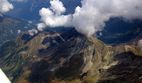
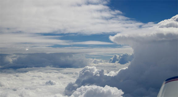
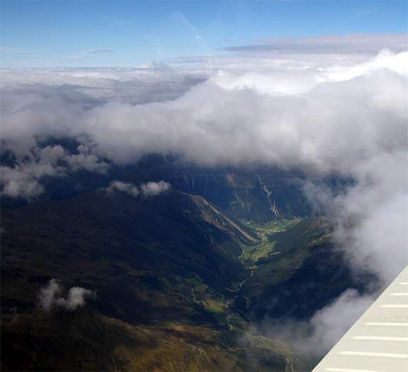
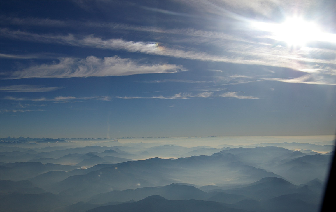
Germany was easy, clearing us to any level up to FL095. Austria likewise, where we gradually climbed to FL145. Over the Alps we were in between some pretty impressive cloud layers, with the mountains and the valleys visible down below. There was a great deal of TCU and CB activity up there but the flight was completely smooth through many small changes of heading to avoid the stuff that was rising up, and remaining VMC so as to not fly into anything nasty. The extent of the cloud cover over the Alps was more or less as forecast, as was the icing level.
In Italian airspace, the military area LI(R) 49 turned out to be inactive and they gave us a direct to Trieste very soon, so we cut out the huge dogleg through WP1 and saved at least 10 minutes.
The crossing of the Alps was a lot easier in airspace terms than our previous one in 2004 from Switzerland; Switzerland had Class C base at FL130 and did not let us climb into it, which kept us about 1000ft above a lot of the terrain. This time, there was no problem with levels and we could have climbed to FL195 in both Austria and Italy. Unfortunately the extent of cloud cover was greater so apart from spectacular cloud formations there was less to see of the ground.
The descent into Trieste from FL140 was steep, and I had to do a left orbit to get down in time. We got a straightforward left base join, and there was no other traffic about.
We did not see any other light aircraft on the entire route, and heard almost none on the radio.
The #1 trick in flying is to never leave the aircraft until one has had fuel! All airports are very keen to get the crew off airside and refusing to go until fuel arrives ensures that it turns up. At Trieste, one has to taxi to a rather remote piece of concrete, just big enough to turn around on with the towbar, to find an Avgas pump that (like most things at the airport) looks like it has not been used in decades and looked like something out of Mad Max:
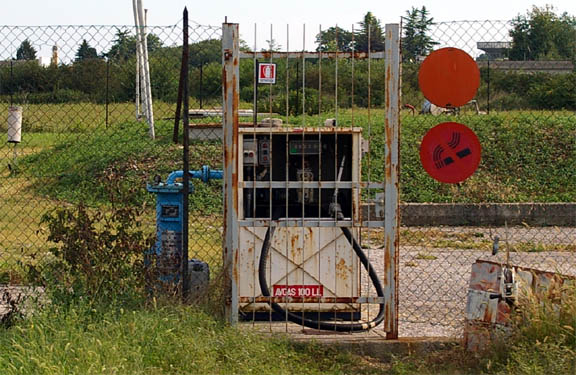
After a while a very friendly man turned up... As with every European airport I've been to outside the UK, one can get duty free Avgas on production of an AOC - which I didn't have. Spain is the one exception, where one can get the very much lower price on production of any evidence of a company owned aircraft. I have an Air BP fuel card in the name of the limited company. The Air BP fuel card was accepted everywhere except Cannes where the Total Oil rep absolutely refused to accept a fuel card from a competing oil company...
Trieste is a very beautiful city, with very friendly people everywhere. The architecture resembles Prague; unsuprising as both were in the Austro Hungarian Empire and the Hapsburgs intended Trieste to become the sea port for Central Europe. A lot of the grand buildings are run-down and many of the most grand ones are empty and clearly have been for decades, with the window frames practically falling out. There is a lot of restoration work going on.
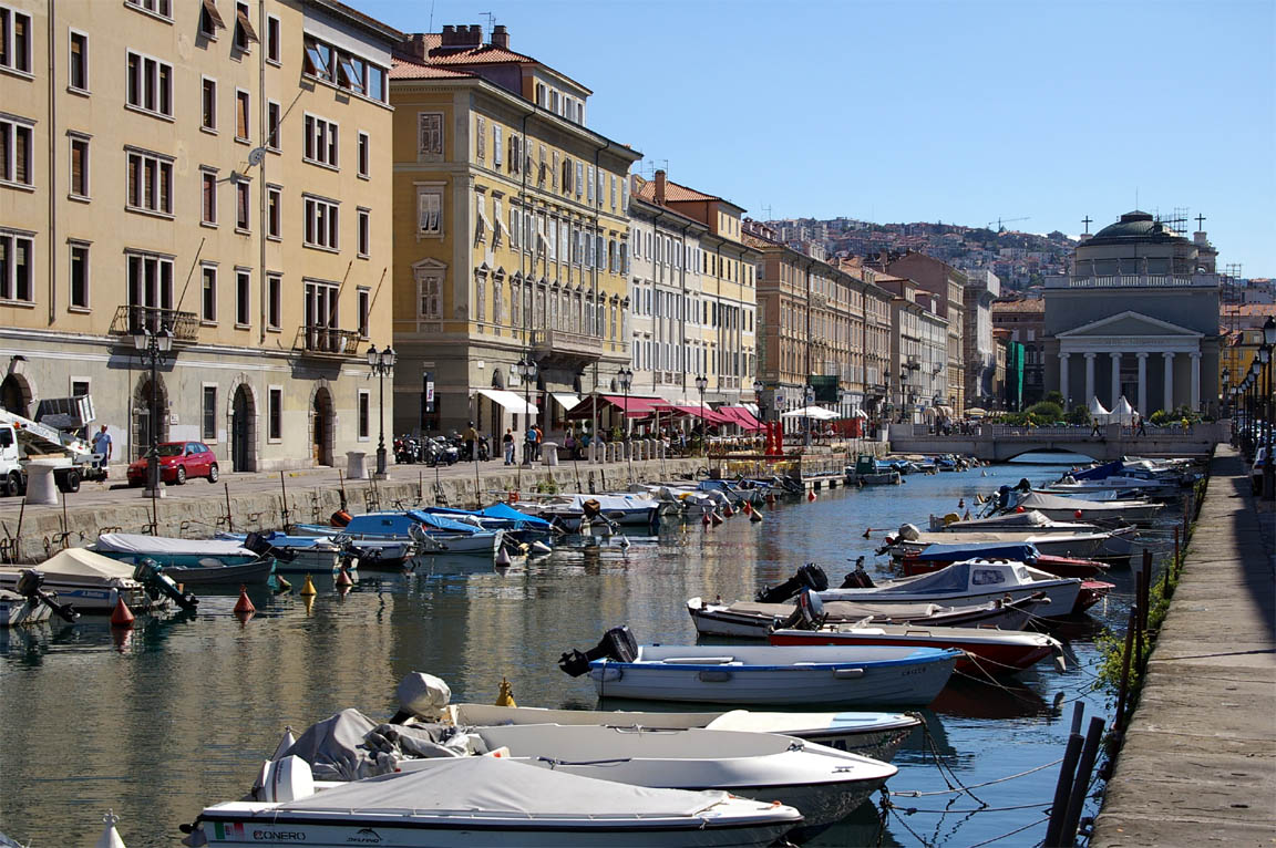

Being Italy, plenty of this:

Trieste - Corfu 15/9/2005
The city of Trieste is some distance from the airport. We took the #51 bus to the airport; 40 minutes. The taxi from the airport 2 days before was 20 minutes but cost Euro 50. Corfu requires 24 hours' notice for VFR arrivals which was faxed the previous day. (A telephone call to Corfu yields the information that they need 5 days PPR but that is just a Greek official doing his job). Note that the Corfu airport is called Kerkira in Greece.
The route (FliteMap image) was
LIPQ GEMKA RJK ZDA SPL DBK MOKUN TAZ RODON GRIBA PITAS LGKR
and was flown mostly at FL050-FL095. The national boundaries are GEMKA, MOKUN, PITAS and the route was modified at the last minute as explained below.
There was a problem the night before with filing the flight plan via the normally excellent Homebriefing online flight plan filing service run by Vienna ATC. The FP was refused with a blank explanatory message. So I telephoned them (at 11pm!) and a most helpful man explained there was a problem with the EETs. The FP contained four separate EETs (estimated en route times) to national boundaries, and apparently I had entered these in nonsensical order. He took them over the phone and filed the plan. The departure, the following morning, went smoothly, with extremely helpful staff at the airport. One turns up at a desk called General Aviation and that's it! The man there advised me that there was a further problem with the FP, with Serbia/Montenegro not liking one of the waypoints I used in their airspace and sending a message to Trieste ATC to that effect. I have yet to check this out properly but despite me using fully up to date aviation data it looks like one of the airway intersections had "disappeared" - this happens regularly with non-ICAO waypoints when SIDs/STARs get re-arranged. Serbia ATC suggested a different route which was sent back to them by Trieste as acceptable and off we went. Their helpful people even extended to the tower staff; the ATCO came down from the control tower and walked up to us loading up the aircraft, handing us the fax from Serbia as they too were interested in the route.
There is a lot of suspect looking NATO airspace along the route, near Serbia-Montenegro so I had telephoned the major airports along the route while still back in the UK, asking them whether they were likely to allow the mainly VOR-VOR route; they were very positive giving a choice of the proposed route, or the VFR routes shown on the Jepp charts. Obviously I took the VOR routes. The man at Tirana ATC was the best of them all... once I found out his phone number which I had to get from Corfu ATC; the widely published Tirana number is a family which is thoroughly sick of it!
The weather data indicated the flight would be in mostly clear weather, which it was. The flight was uneventful, with Trieste initially asking us to fly via a nearby VFR waypoint, not the filed route which was direct to a VOR. After that, we got cleared everywhere without any fuss. Serbia gave us a direct-to through their airspace, bypassing the entire route they had suggested a few hours earlier! Albania were very professional too. Most of the route was at 5500ft, climbing to 7500ft, and finally to 9500ft to clear the terrain over Albania, then a steep descent to Corfu which we only just managed in the 30 miles or so that were left, by dropping the gear about 15 miles out.
It was hot (+7C at 9500ft) and very hazy all the way, with the stormscope showing a great deal of activity ahead but it got the range wrong (estimating it much closer than it actually was) so when we landed at Corfu the activity was still showing 10-20 miles away. The forecast for Corfu did suggest scattered CBs in the vicinity.
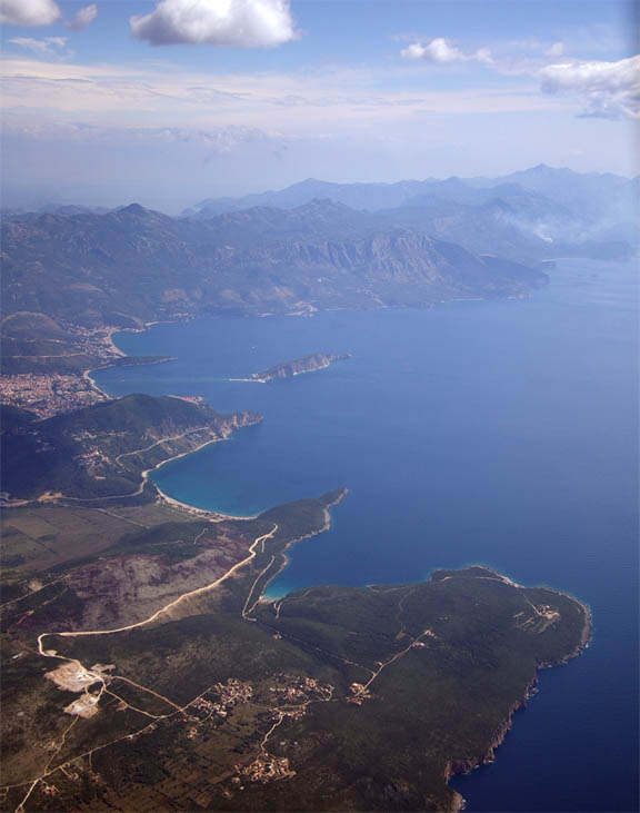
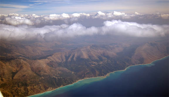
The flight went past plenty of spectacular terrain. The Croatian coast took up much of the distance and is very mountainous:
Albania then gets even more mountainous:
I am convinced the Albanian airways intersections are all named after well built Albanian women who routinely climb up and down those mountains (GRIBA, etc)...
No other aircraft were seen or heard on the radio along the entire route.
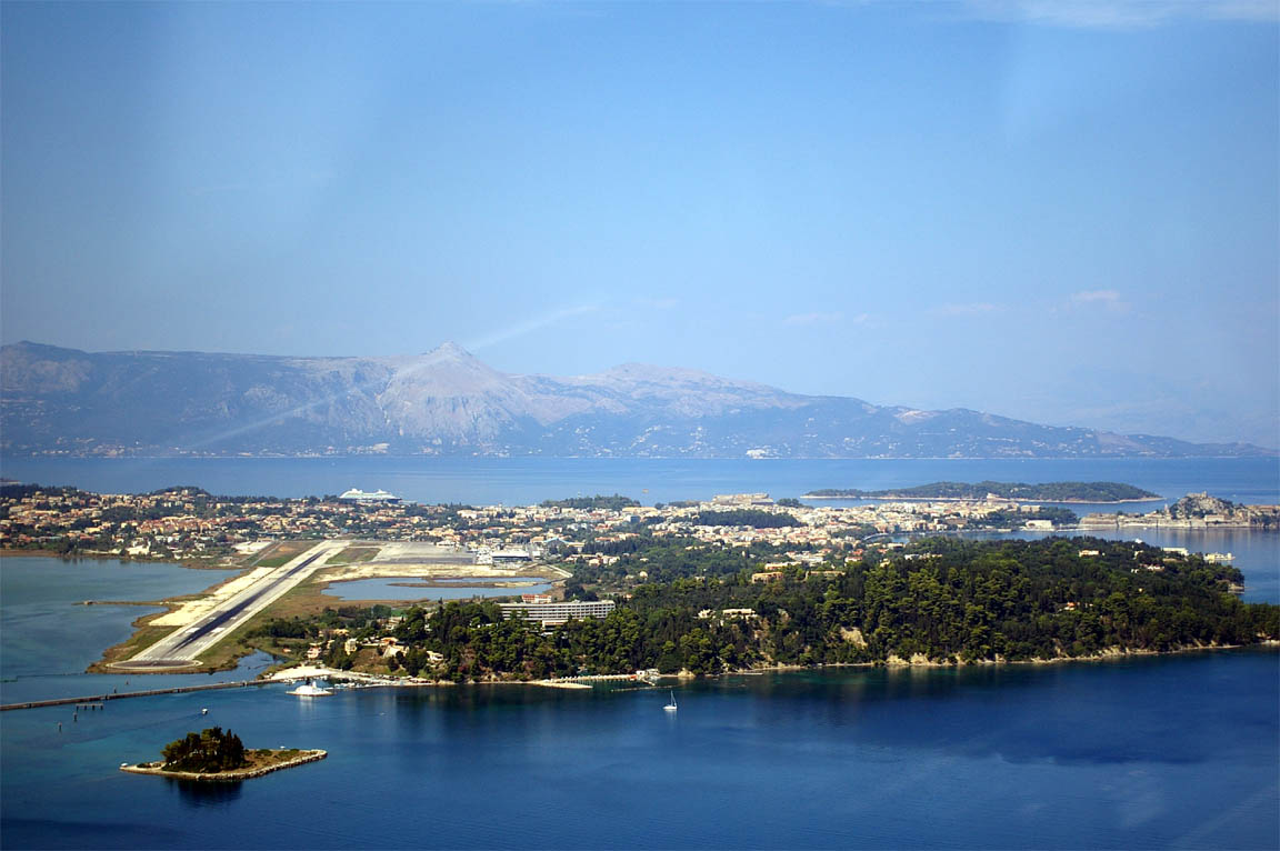
Corfu ATC cleared us for a downwind join for a RH circuit onto runway 35, shown here from the base leg:
The whole process at Corfu was far smoother than on our last visit 1 year previously. Avgas turned up within 10 minutes (I had asked for it while still taxiing after landing) as did an extremely helpful man in a van from Olympic handling. For some reason Olympic initially thought we had arrived from Albania but we were out of the airport as quickly as we could sort out what to take and what to leave.
Corfu is a super island to which I have now flown 4 times and we really like it - much more than southern Spain for example. Everyone there is very nice and friendly and it combines a European flavour with great Greek food and climate.
We did a day boat trip to Albania - picture gallery. It was very interesting; with a super guide who is a schoolteacher. Albania is a very rugged country in which driving anywhere takes many hours; we just did a one-day coach trip which included some archeological sites. Albania is still recovering from having been in a particularly dark version of the communist Dark Ages, right up to 1990. Being a Czech myself I could understand it. However, they are moving ahead and satellite dishes and mobile phones are everywhere. A lot of Albanians are apparently working abroad and spending their money on buying up multiple apartments back home - these people will become extremely wealthy in years to come. Inevitably, of course, what we saw was only a very small and selected portion of Albania; a friend who has done a long visit reports that most of Albania is populated by very poor people with donkeys and occassionally one sees a Merc with blacked-out windows carrying, presumably, the head of the local "business community".
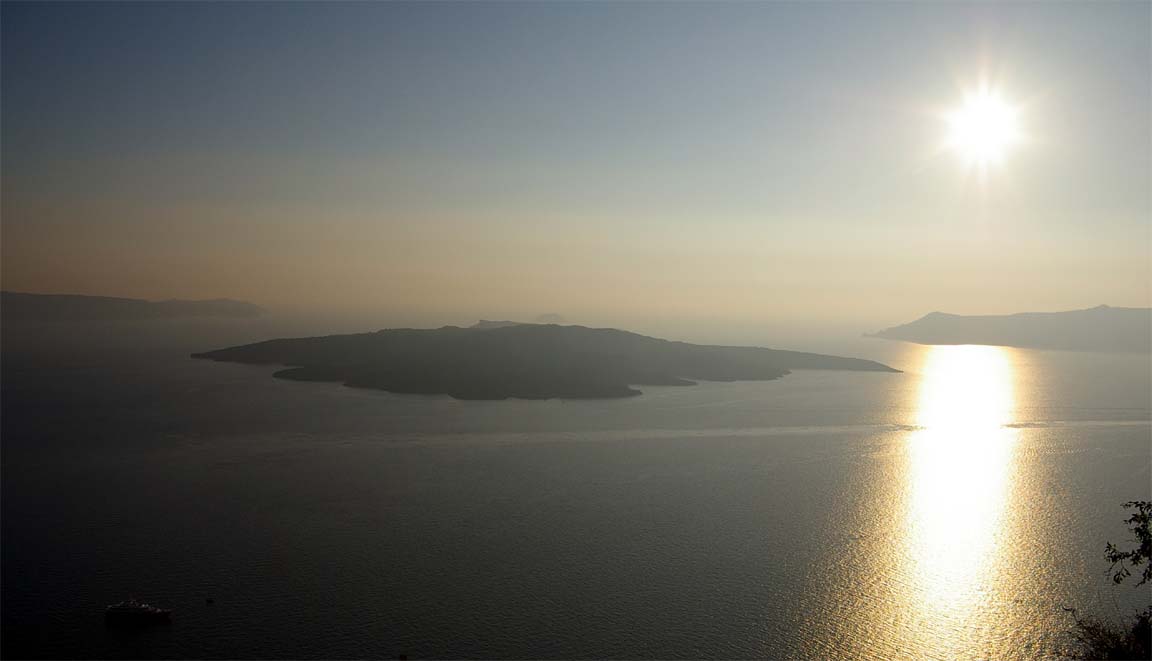
Corfu-Santorini 17/9/2005
The flight plan was filed fine through Homebriefing as I always do nowadays even if facilities are provided at the airport, because the airport is not the place to find problems. The route was mostly along A14 and the FP route (FliteMap image) was just
LGKR A14 MIL N134 LGSR
As I had already filed the flight plan via the internet, there was no need to go up to the tower. However, I had the watch set to the wrong time: Greece was on "summertime" which was UTC+3 and I thought it was UTC+2. I am convinced I was not the only one in Greece with the watch set wrong however, otherwise we would have missed the boat to Albania the previous day. However it meant that the flight plan was filed for a lot later than was convenient and to save hanging around the airport I went up to the control tower to get ATC to amend the departure time to about an hour earlier. They were very helpful as always. The only problem is that to get to the tower one has to go airside and be escorted by an Olympic handling person; Olympic charge handsomely for this very good service at about Euro 50. The landing fee appears standard for Greece at about Euro 30. One can knock a bit off these amounts if there are zero passengers (i.e. if every person carries a pilot licence) but on the scale of flying costs and on a one-off visit it isn't worth the time worrying about it.
We got escorted all around by a woman from Olympic Handling and everything was dealt with efficiently. On the day (Saturday) the airport was really busy. Apparently, Tuesday and Thursday are the best as they are quiet. The total cost, landing and 2 nights' parking and Olympic handling, was Euro 80 which would be very reasonable for a large airport in the UK.
We departed from runway 17 (the best way to depart at Corfu since the holding point is just yards from the GA parking spot, so when engine tests are done you can call "ready for immediate") and were cleared for a left turn back to overhead the runway and to the west coast of the island. I asked them for a direct to KRK (which is on the route) which they initially refused due to traffic reasons but very soon after takeoff they cleared us to KRK at not above 1000ft.
The flight was mostly at FL095, to clear some terrain along the route and to get above the haze layer. ATC kept a watch on us, asking for estimates to various waypoints.
Shortly after departure from Corfu and while climbing through 4000ft, the Honeywell KFC225 autopilot failed - about the seventh time since the aircraft was new in 2002 and it's now quite a long story. The roll servo error indicator suggested it is the same fault which has happened several times already. Given how tightly regulated (and buried in paperwork) everything in aviation is, it's astonishing to discover that a "certifed" autopilot can be designed so poorly that it passes the power-up tests with a roll servo on which a major component has melted and fallen off the PCB and which is completely dead as far as any motor function is concerned (yes I have verified this personally). As a result of this poor record, Honeywell have offered an effectively indefinite warranty on the autopilot system so I made some phone calls to organise a replacement when back in the UK. However it does mean we had a lot of hours ahead of us without the autopilot, which means a much greater pilot workload. Fortunately the TB20 is very stable and needs minimal input in roll and even less in pitch - in still air!
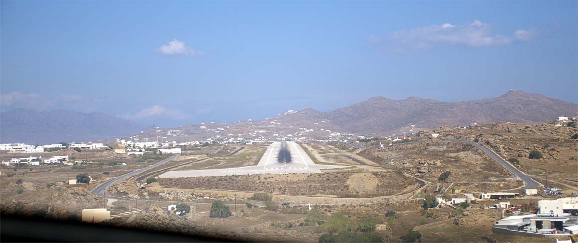
Due to haze, we did not see Santorini until we were about 20 miles away. One is supposed to be under 2500ft before reaching the Santorini TMA. Arriving from the west, it's VOR is not working due to the terrain immediately west of it until one is nearly overhead; this doesn't stop ATC asking for "DME distance". In the descent we were doing about 190kt TAS (about 210kt GS) and Santorini ATC queried this; perhaps it seemed too fast for the aircraft type. We were cleared, in unclear terminology, for a crosswind join for a right base onto runway 34R. The island has two parallel runways, both approximately the same size. Both the 1 year old Jeppesen Bottlang guide and the current Jepp approach plate did not show both runways (though they suggest there is one more, by using a "34R" designation) so this was interesting! Clearly 34R/16L gets a lot more use than the other one so perhaps the latter is a new addition, or an old taxiway recently redesignated as a runway.
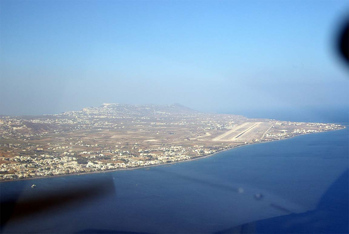
The island looks quite spectacular from the air and from many places on the ground: picture gallery.
There is more than ample light aircraft parking on the apron. It was off-season but there were still four B737 jets parked, loading and unloading tourists. There were a couple of old aeroplanes which had been pushed up a very steep road and might have been vandalised; perhaps they tried to depart without paying their landing fees....??
The process at the airport was fast. We got collected by a huge bus used to ferry tourists to the 737s. The CAA people were very friendly, assuring us there was no need to pay the landing+parking now as it would take "5 minutes" before departure. Olympic Handling are also involved and need to be advised at least a day before arrival to "organise things" - not that anything actually needed organising.
Santorini is an absolutely spectacular location to visit just for its views. These can be seen from any of the many restaurants and cafes and the best ones by far are on the west side of the island, looking into the caldera.
There are worthwhile boat trips to nearby islands and parts of the volcano which is not dormant! We did one day boat trips to Paros (to meet a Greek pilot friend) which was partly on a 40kt turbine powered boat carrying as many people as a large airliner. We also did a really nice one day trip around the Santorini islands; the very laid-back small island of Thirasia (no hotels!) is definitely worth visiting. Be careful not to step on the sea urchins which are all over the beach, just below the waterline!

As in Crete, the people are very friendly and most speak good enough English. The island is very expensive; it is a seriously upmarket shopping location, with plenty of Euro 4000 watches and jewellery on sale. The restaurant prices are top European-city prices and occassionally higher! The food is universally excellent and anyway Greek food is the most healthy one can find in Europe. One needs to have some cash as some places suprisingly don't accept credit cards. The side with the volcano views is a lot more expensive!
This was the first time on our numerous trips that we had slight trouble finding a place to stay. After a lot of walking up and down the side of the volcano in the scorching heat I found a super place called an "Art Cafe" and we got a fantastic apartment cut out into the side of the hill. At Euro 150/night, about half the normal rate, it was good value by Santorini standards.
Santorini has significant downsides: even off season (we were there around 20th September) it is packed with too many tourists for its small size. For some reason the island - much more so than any other location we have been to - suffers from a great deal of crude commercialism in which a lot of the hotel/restaurant owners, taxi drivers, and many others, seem to assume that nobody will ever come back again, so it's OK to rip them off openly and to be generally rude. The airport taxi driver dropped us a few hundred metres short, to pick up somebody else who waved him down; there is a lot of very forceful touting; one has to carefully check the price of everything one is ordering in a restaurant (might get a Euro 30 bottle of wine when reasonably expecting a Euro 5 one); the public toilet has an attendant who sells you approximately 1 metre of toilet paper to enter; taxi and bus drivers won't even talk to you. As a result, and due to the island's small size limiting how much one can do there (apart from expensive shopping) I suspect most tourists never come back. The place needs a serious crackdown on the rogue traders. Also, considering the Switzerland-level prices, it could be a lot cleaner. This is all unfortunate because most of the native people there are really kind and welcoming. Perhaps the reason for the behaviour of the "few" is that the island is pretty dead during the winter months, so some tradesmen feel they have to make as much money as they can during the few months of the tourist season. However, Corfu manages to hold a much higher standard despite receiving a lot more of the noisy beer+chips tourist crowd than Santorini does.
The weather in the area is generally very nice but there is a lot of humidity and heat about which results in brief periods of stormy weather which is not at all evident from the MSLP charts alone.
The landing and four nights' parking at Santorini came to Euro 90 which is perfectly reasonable. What was not reasonable was the time it took to go around the various airport departments doing the seemingly pointless form-filling, but that appears universal in Greece. There is no doubt a way to do a deal with Olympic handling to smooth the process for frequent flights, using fax/email prior notifications.
Santorini has no Avgas and the nearest is on Mikonos. The TB20 can do the round trip from Corfu to Santorini and back with about 2:30 fuel reserve but on the day of departure the forecast wind (at FL100) of 25kt would have eaten too much into this reserve, and together with a PROB30 of CBs at Corfu (making a weather diversion a realistic possibility, and then where does one get Avgas???) I decided to stop at Mikonos for fuel.
At this point it became apparent that the trip would be cut a couple of days short because the weather coming back to the UK looked very bad, with a series of closely spaced and powerful cold fronts.
Santorini-Mikonos 21/9/2005
This was a fuel stop only. The route was direct LGSR-LGMK and the flight time was under 30 minutes. We flew over Paros and other islands on the way there.
Mikonos did not require prior notice but I got the OPS man at Santorini to phone them anyway. A flight plan was filed as previously via Homebriefing, and I filed the onward FP to Corfu at the same time, allowing 2 hours for messing around. Most of this time got used up filling in the traditional Greek airport forms. There is a statistics collection form (comprising of around five parts; Greece must be covered in filing cabinets by now), an ICAO Annex-something health declaration for all on board, and some other stuff. The landing fee came to Euro 12; the Civil Aviation Authority official said we don't have to pay the Olympic handling service which was reasonable since we didn't make any use of it.
The fuel man at Mikonos acceps only cash, which was a bit of a shock especially as the cash machine at the airport was faulty. We managed to get just enough together...
Mikonos-Corfu 21/9/2005
The route was the exact reverse of the Corfu-Santorini route except departing from Mikonos: LGMK DCT MIL A14 LGKR and was flown between FL085 and FL125. There was a fair amount of scattered cloud building up and we remained above it, using oxygen at FL125, so we could visually avoid any TCU/CB activity. The forecast for Corfu was a PROB30 of thunderstorms but in reality there was nothing. The wind was right across the runway at 10kt and we were offered a choice of 35 or 17; we took 35 as it was straight-in. Corfu ATC were very helpful as always. Wednesday afternoons are evidently very quiet at Corfu, judging from the empty airport.
The waypoint PAXI which is just south of KRK is shown a few miles out in the sea in the Jeppesen GPS data (in the KLN94/KMD550) to its correct position on the island of Paxos; curiously the Jeppesen Bottlang guide shows it correctly. Yet Jeppesen don't publish any VFR charts for Greece; instead including very out of date ONC charts in their "VFR Raster Charts" package. This reveals the complex legacy of old printed data versus electronic data which Jeppesen evidently struggle with, but this time it is the supposedly regularly updated electronic data which is wrong.
According to Notam, Corfu requires 24 hours notice which was faxed the previous day. I asked the very helpful CAA official at Corfu why their Notam says "24 hours notice" whereas their staff say "5 days prior permission" when telephoned. He explained that the Aviation Ministry requires them to regulate their apron capacity and they can't do this on a "notice" basis because anybody could just turn up. However, I've never seen more than a few planes (about 5% of capacity) on the GA apron! Fortunately it appears that a fax giving a range of dates is fine.
Corfu-Cannes 22/9/2005
Up to Corsica, this was along the same route as we flew in 2004 from Corfu to Corsica (FliteMap image):
LGKR TIGRA BRD GIO SOR PNZ MOULE NORKA LERMA LFMD
The national boundaries are TIGRA and MOULE.
Most of the route was flown at FL095 and Italian ATC were really helpful; much more so than in 2004. What the above FliteMap vertical route profile doesn't show is that a large section (around SOR/PNZ) has to be flown at 2500ft or 1000ft under the mass of Class A airspace and too far from the Italian coast for any VHF radio contact. Obviously we carry a covered raft, an EPIRB, an emergency radio, etc and all this had to be ready as the time to ditch following an engine failure would be under 1 minute. I did ask for a SVFR transit (unlikely as it is a TMA, not a CTR) but they refused, citing "traffic coordination" reasons; complete bull of course as no traffic would be at 1000-2000ft that far away from any airport.
This time, we flew past Corsica. Bastia in Corsica was (in 2004) a very difficult airport, with nobody being able to (or wishing to) speak English and it took us hours to get through the airport. This time I faxed and emailed the Bastia Aeroclub which we saw on our last visit (in the hope that passing through it would cut out the problems) but they never replied. I then phoned them but nobody there could (or would) speak English. I asked a friend in France to telephone them, which he did and reported that they said the main airport should be just fine... It is also possible that there is more than one aeroclub and I was trying to contact the wrong one. So I gave Corsica a miss and flew all the way to Cannes. This also gave us a shorter final flight back to the UK of about 4 hours - desirable given the rather dodgy looking weather patterns.
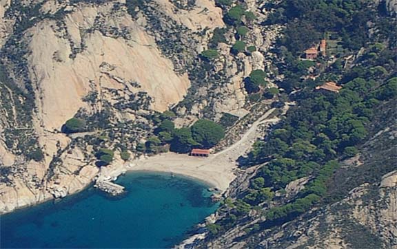
As before, we flew past (and around) Monte Christo Island
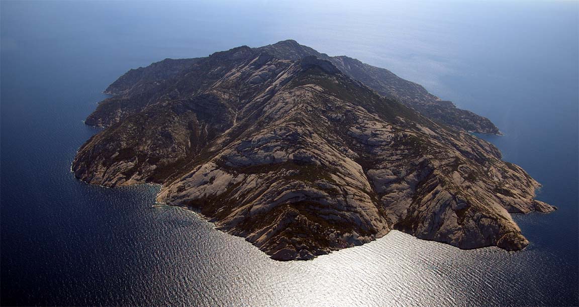
The island appears barren but a close-up from its other side shows that there is something there....
Monte
Christo Island video (Adobe Flash .flv, 31MB)
Monte
Christo Island video (Ipod/Iplayer .mp4, 42MB)
We flew over Corsica, taking to Bastia approach right up to NORKA. Near Cannes, one contacts Nice Approach and they suggested an approach into Cannes via LERMA (previously I had not flight planned via LERMA).
The approach into Cannes was a downwind join onto a LH circuit to land on runway 17

Cannes is far and away the slickest smoothest major airport I've ever been to - unsuprising given their upmarket clientele which consists mostly of turboprops and jets:
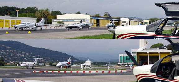
The airport has desks for NetJets and a few other exec jet companies.
Cannes is a lovely town with great views all around
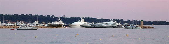
I have never seen such a concentration of seven-figure (occassionally eight-figure) priced boats so unsuprisingly Cannes is an expensive shopping location...
To beat a nasty looking cold front moving into the UK, we got airborne the following morning at 0800 local (the airport opens at 0800) and all the relevant staff except admin were already in place and all looking very smart and on the ball. All one does on departure is fill in a form with credit card details and, in the absence of the staff, pop it into an envelope and pop the envelope into a letter box in the main hall. Then you just walk straight through the x-ray, Customs and straight to the aircraft. One can do the lot in 5 minutes. Why aren't all airports set up like this, to make life easy for people using them? I suppose that GA just doesn't feature on the horizon of the administration of most larger airports. Cannes however is set up for business aviation... There were a couple of jet movements even before 0800. The invoice arrived by airmail a few days later: total Euro 34. Fantastic!
Cannes-Shoreham 23/9/2005
The route back to the UK over France (FliteMap image) was the "airways" one
LFMD STP MTL MOU NEV MOTAL KOVAK LGL DVL SITET EGKA
with SITET being the UK FIR boundary.
The weather data indicated that we should start off as early as possible. A cold front (MSLP chart) was moving in as as this would be moving into France later, we would have been stuck for a while.
Departure from Cannes was via runway 17, followed by a right turn along the coast (not below 800ft) towards STP.
The flight went absolutely smoothly, mostly at FL085/095, with the French sort of "radar information" (and implicit clearances through any CAS) all the way. A part of the time we were with Paris Control. Around the French Alps we got spectacular views of the morning mist covering the mountains:
The early departure from Cannes paid off and we beat the nasty weather by two hours - exactly as expected. Initially we had about 10kt headwind but later, as forecast, this became a tailwind.
Aircraft Performance
The TB20 is a perfect aircraft for this type of flight. Of course one could use 250kt but that comes at a vastly increased cost of a turboprop. With oxygen, one can get above most weather in a TB20 - TCUs and CBs excepted.
Apart from the Honeywell KFC225 autopilot (whose unreliability is legendary; it has failed in nearly every aircraft it has been fitted in, and if Honeywell have the slightest idea what the problem is they show no sign of it) the aircraft performed perfectly, and was very easy to fly by hand too. What one cannot do is fly it by hand while talking to ATC, while taking photographs, while changing waypoints in the KLN94, while having lunch.
It's a pity that Socata have temporarily stopped manufacture of the TB series. Depending on the market conditions in the USA (their main market) and the US$ exchange rate, they may or may not restart production. They will need up to date avionics, for Europe a diesel engine, and of course a working autopilot! Not to mention a major overhaul of customer service in Europe. In the meantime, the bad publicity resulting from the announcement of the production stop has killed what market there remained for TB aircraft. The current completely mad UK government proposal to kick N-registered aircraft off UK soil after a stay of 90 days has finished things off nicely - almost everybody wishing to fly IFR in Europe will be doing so under FAA licenses which means an N-registered aircraft which means sales of IFR singles will be low for the foreseeable future.
The following picture was taken on an airways (IFR) flight over Eastern Europe at FL120 but it's a curious observation that outside the UK - and assuming VMC and avoidance of Class A - one can do very similar flying under VFR, and talking to the same ATS units too. One cannot do this in the UK because there are too many bits of Class A, and because one doesn't get the service from the en-route IFR ATS units. The really good VFR clearances are not offered - you have to ask, ask confidently, and then fly it accurately and with good radio procedures otherwise they get nervous.
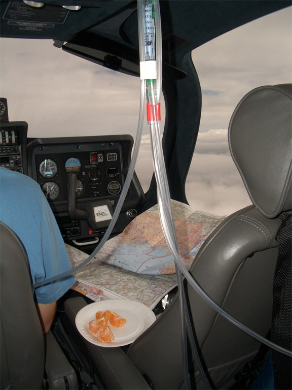
In-flight catering at FL140; the things handing down from the ceiling are the oxygen flowmeters (more info) which need to be vertical to display the flow rate correctly:
Flight Times
EGKA-LIPQ 4:50
LIPQ-LGKR 3:20
LGKR-LGSR 2:25
LGSR-LGMK 0:30
LGMK-LGKR 2:35
LGKR-LFMD 5:05
LFMD-EGKA 4:05
The zero-reserve endurance of the aircraft, at FL100 and about 155kt TAS, is about 8 hours. The above flight times are very comfortable provided the people know each other :)
Lessons Learnt
Airspace transits: Without doubt the biggest lesson was the ease of getting CAS transits through Belgium, Luxembourg, Germany, Austria and Italy. Unfortunately one cannot rely on transits in advance of the flight but at least one can be fairly sure that the lengthy routes that have to be planned will usually not need to be flown.
Moving map GPS using Jeppesen FliteMap: As you can tell, I like checking out gadgets! However the ix104 tablet computer is a bit too clumsy to be fully useful. It is heavy, gets very hot, and the display is not sunlight-readable. They do a much better display but it's an expensive upgrade. Jeppesen FliteMap (I had the very latest version, 9.14 built 9118) is not reliable enough as a GPS moving map, showing up various bugs: it sometimes runs very slowly, often the aircraft fails to remain in the centre of the screen so one has to pan the map manually, and occassionally the position shown is several miles off track until one closes and restarts the program (there appears to be a rather dangerous bug in their moving map software, perhaps limited to certain chart types). The whole user interface is too clumsy to work with the pen in the cockpit. This is a pity as there is no alternative product that has anything like decent maps. Jeppesen have a virtual monopoly on GPS aviation map data so they get away with selling poor software to use it with. If Navbox had reasonable VFR map data, worked really nicely as a GPS moving map (as well as OziExplorer does in basic GPS mode), and fixed a few quirks (like the very slow map redraws) then few private pilots would bother with the clumsy and overpriced Jeppesen products, and this is true for both VFR and lower-airspace IFR.
FliteMap/FliteStar for flight planning: Navbox is much more usable, except for airways (IFR) usage where FliteMap's semi-automatic route generation is a handy feature. FliteMap works best on a large monitor (1280x1024 or larger). FliteMap does a lot more than Navbox, at the cost of several times as many mouse clicks to do anything comparable! Additional notes relating to IFR are here.
Fly HIGH: there is no doubt that outside the UK one can get more ATC clearances when at 10000ft than at say 3000ft. I guess this is because one is more likely to get overhead transits over busy airports, but also because telling ATC in a very straight manner that you "request transit ABC to XYZ at FL100" (where ABC and XYZ are VORs or intersections, not VRPs) tells them that you know what you are doing. The pilots who are unsure of their navigation tend to fly low down, and ATC are just not interested in them - particularly, I suspect, in countries where there is very little GA activity. I think the whole purpose of the published "VFR routes" is to keep these pilots out of harm's way, when they are flying in their local area where they know the ground features. 15000ft is even better - one just needs a bigger oxygen bottle!
Contact Numbers
These phone and fax numbers were identified and used on this trip. Most of them were wrong in all the touring guide and flight planning software data. A good trick for discovering numbers for ATC is to phone up the ATC of another, preferably large, airport.
It's worth noting that we saw or heard few light aircraft along the entire route, once out of the UK. There were one or two in Belgium, Germany and France and nothing beyond that. Yet all the countries transited are wealthy enough, so what has killed off their GA (general aviation) activity? In Greece, it is probably the ridiculous regulations which make flying there a constant source of little problems, together with a shortage of airfields.
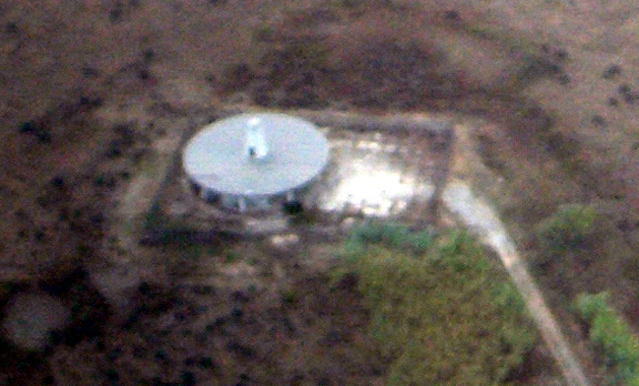
And finally, one for the VOR spotters - the KRK VOR :)
Last edited 23rd February 2009
Most of the pictures in this article were taken with a Pentax DL digital SLR, 6MP. The contrast is not great due to the haze which was just about everywhere.